Riparian Buffers
Purpose of Riparian Buffers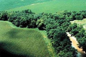
Riparian (stream) buffers help promote good water quality.
- Buffers remove pollutants such as oil from roads and nutrients from over-fertilized lawns.
- Buffers also slow floodwaters, trapping sediment to help build stream banks and protect downstream property.
- By slowing down runoff, the buffer vegetation allows water to soak into the earth and recharge groundwater.
Requirements
- In Apex a 100-foot buffer is required on any stream that flows year-round (perennial stream) and a 50-foot buffer is required on any stream that flows only part of the year (intermittent stream). The lengths are measured from the top of bank.
- The Town Unified Development Ordinance (UDO) lists the buffer zones and allowable uses within each zone.
Riparian Buffer Impacts
If someone wants to build in or otherwise disturb a riparian buffer, certain documentation is required. Please refer to UDO Section 6.1.11(G)(1) for the Table of Uses to see the list of what is "Allowable".
- If a use is listed as Allowable, please submit a Request for a No Practical Alternatives (PDF) determination to the Town for authorization.
- If according to the Table of Uses mitigation is required, a Buffer Impact Mitigation (PDF) form must also be submitted.
Watershed Protection Overlay District Map
The Watershed Protection Overlay District Map (PDF) illustrates the buffered streams in Apex.
- A shaded green buffer represents a 100-foot buffer on a perennial stream.
- A blue shaded buffer represents a 50-foot buffer on an intermittent stream.
- The Primary Watershed Protection District (red area) is land identified by the State as water supply watershed protected areas.
- The Secondary Watershed Protection District (orange area) is all other land within Apex corporate limits and ETJ.
Homeowner Information
Please note that within the buffer, it IS allowable to:
- Prune vegetation
- Remove dead trees
- Remove nuisance vegetation (such as poison ivy, vines, and bamboo)
Stream Determinations
For a stream determination to be completed for your property, please have your environmental consultant submit a Stream Determination Application (PDF) along with required, supporting documentation. For your reference, an example of a completed application has been provided. Note that a Right of Entry form is one of the required items on the application. All stream determinations will need to be submitted through IDT/GeoCivix for review and scheduling. Please see our Electronic Plan Review page for more information on how to register and upload your documents.
Note: The Town of Apex is a delegated authority to perform stream determinations in the Upper Cape Fear basin. The State of North Carolina conducts stream determinations in the Neuse basin and Wake County conducts stream determinations in the Upper Cape Fear basin for properties outside of the Town's planning jurisdiction (in the county). Please ensure the subject property is in both the Upper Cape Fear basin and in the Town's planning jurisdiction.